When it comes to China’s most representative rivers, the Yellow River (黄河), the Yangtze River (长江), and the Huai River (淮河) immediately come to mind. These three rivers have been deeply intertwined with the development of Chinese civilization and continue to be key drivers of modern China’s growth. In this post, we will explore their historical, cultural, and economic significance.
An Overview of China’s Three Major Rivers
Spanning the vast Chinese continent, the Yellow River (Huang He), the Yangtze River (Chang Jiang), and the Huai River (Huai He) have contributed to the rise of agricultural civilizations and the formation of powerful states for thousands of years. The origins of the Chinese characters for “river” and “jiang” are closely tied to these waterways, underscoring their longstanding importance in Chinese culture.
Originally, the Chinese character “河” (he) did not just mean any river—it referred specifically to the Yellow River. Similarly, “江” (jiang) originally meant the Yangtze River. This linguistic evidence shows how vital these rivers have been to Chinese civilization from its earliest days.
Just as the Nile in ancient Egypt derived its name from an Egyptian word meaning “river,” in China, words for “river” historically referred to the Yellow River and the Yangtze. Flowing north to south across the continent, the Yellow and Yangtze Rivers nourished numerous Chinese states, while the Huai River, situated between the two, served as a cultural bridge connecting north and south China.
The Yellow River: The Cradle of Chinese Civilization
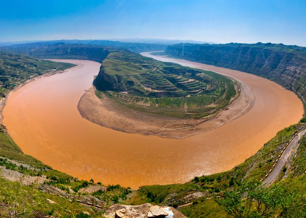
The Yellow River (黄河), stretching about 5,464 kilometers, is China’s second-longest river, flowing through northern China before emptying into the Bohai Sea. Its basin is widely considered the birthplace of Chinese civilization, dating back some 5,000 years. Given that the character “河” once referred specifically to the Yellow River, it is clear that this waterway has long been central to Chinese life.
The Yellow River carries large amounts of loess from the Mongolian Plateau, giving the river its signature yellowish-brown hue. This loess enriches the surrounding soil, making it ideal for cultivating grains such as soybeans and millet. The agricultural abundance along the Yellow River was critical in the rise of early Chinese states. Dynasties like the Xia (夏), Shang (商), and Zhou (周) developed around this region and established strong governance structures.
However, the Yellow River has also been a cause for concern, frequently bursting its banks. Consequently, flood control has historically been a top political and economic priority for Chinese rulers. Building levees, improving irrigation systems, and developing flood prediction techniques became nationally important endeavors.
Stories of taming the Yellow River are woven into Chinese legend, notably the tale of Yu the Great (禹王) who is said to have conquered the flooding waters. Even today, the Yellow River region remains a major agricultural zone in northern China, producing large quantities of wheat and other staple crops—continuing its role in sustaining Chinese food security.
Recommended Destination: Zhengzhou Yellow River Scenic Area

Located near Zhengzhou in Henan Province, this scenic area offers a close-up view of the river’s majestic features and highlights its historical and cultural significance. Surrounding facilities include museums, statues, and parks dedicated to the Yellow River civilization, providing insight into the relationship between the ancient Central Plain civilizations and the Yellow River.
The Yangtze River: Economic and Cultural Lifeline

Known internationally as the Yangtze River, the Chang Jiang (长江), at approximately 6,300 kilometers long, is the longest river in Asia and the third longest in the world (after the Nile and the Amazon). As the character “江” once referred specifically to the Yangtze, this river has served as the lifeblood of southern China, just as the Yellow River did in the north.
The Yangtze rises in the Tibetan Plateau, flowing west to east and eventually emptying into the East China Sea near Shanghai. Throughout Chinese history, this vast waterway has facilitated the movement of agricultural products, manufactured goods, labor, and ideas between inland regions and coastal areas. Cities along the Yangtze—Shanghai, Nanjing, Wuhan, and Chongqing—have become economic powerhouses with robust sectors in trade, manufacturing, services, and finance.
Today, the Yangtze generates around 40% of China’s GDP through what is known as the Yangtze River Economic Belt. By dramatically reducing inland shipping costs and linking interior cities to global markets, the Yangtze has become a vital conduit for commerce and industry.
The Three Gorges Dam (三峡大坝), the largest hydroelectric power station in the world, is located in the middle reaches of the Yangtze. Thanks to this massive project, southern China benefits from reliable power supplies, a transition to cleaner energy, and enhanced flood control.
Recommended Destination: The Three Gorges of the Yangtze

Situated between Hubei Province (湖北省) and Chongqing (重庆) along the middle and upper reaches of the Yangtze, the Three Gorges are among China’s most iconic natural landscapes. Sheer cliffs tower over emerald-green waters, creating breathtaking scenery best experienced by cruise boat. Visitors can also delve into the rich history and diverse folklore of the Yangtze region.
The Huai River: Dividing Line Between North and South

The Huai River (淮河) flows through Henan, Anhui, and Jiangsu provinces, meandering between the Yellow and the Yangtze Rivers from west to east. The term “淮” (Huai) originates from the name of this river, which has historically been regarded as a natural dividing line between northern and southern China.
North of the Huai tends to be drier, favoring crops like wheat and soybeans, a hallmark of northern Chinese agriculture. South of the river, the warmer and more humid climate is more conducive to rice cultivation typical of southern Chinese agriculture. Hence, the Huai River is far more than just a physical boundary—it highlights distinctions in climate, land use, lifestyle, and even cultural identity.
Moreover, the Huai region has historically been a critical inland transportation route, once forming part of the Grand Canal (大运河). It linked the northern Yellow River area with the southern Yangtze region, enabling the exchange of agricultural goods, specialties, knowledge, and cultural practices. Ancient towns along the Huai could easily access both rice and wheat, as well as products like tea and pomelos, giving birth to unique traditions and customs.
A famous Chinese proverb states, “Once you cross the Huai, a trifoliate orange (hardier fruit) becomes a mandarin orange (tender fruit),” illustrating the cultural and climatic gap between north and south. Of course, trifoliate oranges and mandarins belong to different species—replanting one in a different region doesn’t magically transform it into the other. Rather, it’s a metaphor for how geography and climate shape culture and living conditions.
Recommended Destination: Hongze Lake Scenic Area

Spanning Jiangsu Province, Hongze Lake is a large freshwater lake connected to the Huai River. It is known in China for its thriving fishing industry and commitment to ecological preservation. Visitors can enjoy vast waterscapes, observe diverse aquatic plants and birds, and experience local cuisine and lake culture—an authentic glimpse into the unique character of the Huai River region.
Conclusion
Together, the Yellow River, the Yangtze River, and the Huai River traverse China’s expansive terrain, leaving indelible marks on history and culture. If the Yellow River is the cradle of Chinese civilization, then the Yangtze is its economic engine and logistics hub, while the Huai serves as a bridge uniting north and south. Far beyond being mere sources of water, these rivers have enriched Chinese society, carried ideas, nurtured agriculture, and fueled urban development. They remain the lifeblood of China—sustaining the past, present, and future.